


We all know the feeling. You're on the expressway, going nowhere fast, and, desperate to discover whether there is an end to the gridlock, you turn on the radio to listen to the traffic report. But instead of an understandable account of the current travel times, you hear this:
"Looking in Melrose Park, 22nd and Lake Street, there was a 3-alarm fire. It has been struck. Crews are still on the scene, though, so that area is blocked off. The Edens looks pretty good. Lake Cook to Montrose still 19 minutes, same outbound. The Kennedy inbound from Diversey to Circle Interchange is your delay. It's 40 minutes from O'Hare to Downtown. Outbound to the airport is 20. The Eisenhower is a slight delay from First to Des Plaines. Thorndale to Post Office is 33. Outbound to Thorndale 29. No problems on the Stevenson. The Dan Ryan inbound no problems. Outbound you have a delay from the Circle interchange to 18th Street where they're working on the ramp there so it's closed at 18th Street. Downtown to 95th is 22. No problems on any of the area tollways delay-wise, but in both directions on the Tri-State at Milwaukee, the left lane is closed for roadwork until 3 o'clock."
Huh? This is a transcription of an actual traffic report recently heard on a certain AM radio station, and even with the luxury of being able to read it slowly, several times, it is still barely comprehensible. Listening to it in our cars, however, we're still trying to figure out whether the fire in Melrose Park can possibly affect us when we realize the report has ended and we're no better off than we were before.
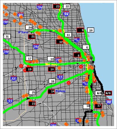
Fig1. The Gary-Chicago-Milwaukee Travel Website provides an overview
of the tangle that is Chicago's highway system.
The typical radio traffic report is comprised of sentence fragments, filled with jargon, and frequently delivered at speeds that would make a state fair auctioneer blush. No wonder, then, that these reports can baffle and frustrate even the most hardcore native Chicago driver. This guide attempts to demystify the local traffic report by providing a glossary of the major terms used for highway names, directions and locations. For additional help, the guide also includes an annotated list of local traffic and travel resources on the Web.
Finally, I am indebted to Josef who originally suggested this topic for Ask the Librarian. Thank you.
Glossary of Terms
Bishop Ford Freeway (I-94): Originally known as the Calumet Expressway, the Bishop Louis Henry Ford Freeway was renamed in 1996 after the long-time pastor of St. Paul's Church at 4528 South Wabash in Chicago, who passed away in 1995. The Bishop Ford first opened in 1950 and serves as a connection between the Dan Ryan Expressway and I-80 at the Indiana border.
Circle Interchange: The Circle Interchange refers to the spot at Congress Parkway where the Dan Ryan, Kennedy and Eisenhower Expressways meet just west of the Loop. The circle shape created by the twisting spirals of exit and entrance ramps between the expressways at this point gave the interchange its name. Circle Interchange is frequently used as a location marker for travel times, and reporters sometimes shorten it to just "Circle."
Dan Ryan Expressway (I-90/94): The Dan Ryan Expressway, which opened in 1962, is named for Daniel B. Ryan, president of the Cook County Board of Commissioners from 1954 to 1961, and refers to the stretch of I-90/94 that runs from downtown Chicago south to 95th Street. With a whopping 14 lanes, the Dan Ryan is also one of the widest expressways in the world. It links I-57 to the south with the Stevenson and Eisenhower Expressways. Then I-90/94 becomes the Kennedy Expressway as it continues off to the northwest towards O'Hare Airport.
East-West Tollway (I-88): I-88, the East-West Tollway, begins near Sterling, IL and runs west across the state where it ends at the Tri-State Tollway (I-294) near Elmhurst, IL.
Edens Expressway (I-94): The Edens Expressway, named for Chicago banker and highway advocate William G. Edens, opened in 1951 and is one of Chicago's oldest expressways. It was constructed to connect Skokie Highway (U.S. Route 41) with the proposed, but not yet built, Kennedy Expressway. As a result, the Edens begins near Montrose Avenue in Chicago, where it meets the Kennedy, and stretches north to end where it meets Route 41 at Lake Cook Road.
Edens Spur: The Edens Spur is a tollway extension connecting the Edens Expressway to the Tri-State Tollway (I-294) at the northern end of the Edens, just south of Lake Cook Road.
Eisenhower Expressway (I-290): The Eisenhower Expressway, originally known as the Congress Expressway, first opened to traffic in 1955. It was renamed after former-President Dwight D. Eisenhower in 1964. The Eisenhower Expressway (I-290), also known simply as the Ike, extends west from the Loop through the western suburbs until it intersects the Tri-State Tollway (I-294). Then I-290 turns northward, ending at the Northwest Tollway (I-90), where the same road becomes Route 53.
Elgin-O'Hare Expressway: The most hilariously named expressway, given that it neither begins in Elgin nor ends at O'Hare, but if completed as originally proposed, the expressway intends to connect these two places. Currently, however, the Elgin-O'Hare only acts as a bridge between Lake Street (U.S. Route 20) on the west and I-290 on the east.
I-57: At about 358 miles long, I-57 is the longest interstate in Illinois. It begins at 95th Street on Chicago's South Side, connecting with the southern end of the Dan Ryan. I-57 then runs south through the state, crossing into Missouri after passing through Cairo.
Inbound/Outbound: The concept of inbound and outbound might be one of the most integral to deciphering local traffic reports. In the world of Chicago traffic, downtown Chicago is the center of the universe. Inbound and outbound travel, therefore, is relative to whether you can be said to be traveling towards the downtown area or away from it. If you are roughly headed towards the Loop on any of the major expressways or tollways, then you are traveling inbound. Likewise, if the Chicago skyline appears in your rearview mirror, you are heading outbound.
Kennedy Expressway (I-90): Completed in 1960, the Kennedy Expressway was specifically built to provide a direct route from the Eisenhower Expressway to O'Hare International Airport. Originally named the Northwest Expressway, it was rechristened the John F. Kennedy Expressway exactly one week after the President's assassination in 1963. The Kennedy begins where I-90/94 intersects with the Eisenhower Expressway (I-290) in downtown Chicago, and it ends at O'Hare Airport, where I-90 becomes the Northwest Tollway.
Kennedy Junction (Montrose): The Kennedy Junction is the name given to the point at which the Edens meets and merges into the Kennedy Expressway. It may also be referred to as simply the Junction. Because the Kennedy Junction is located near Montrose Avenue, some traffic reporters, such as in the example transcribed above, may also refer to the Kennedy Junction as Montrose.
Lake Cook Road: Lake Cook Road is a major east-west street that, as its name suggests, marks the dividing line between Cook and Lake County in the northern suburbs. Lake Cook Road also marks the northern end of the Edens Expressway.
North-South Tollway (I-355): I-355, known as the North-South Tollway, opened in 1989. It begins in the north in Itasca at I-290 and ends in the south in Bolingbrook, where it connects to I-55.
Northwest Tollway (I-90): The stretch of I-90 designated as the Northwest Tollway starts in the east where the Kennedy Expressway ends near O-Hare Airport. The tollway runs northwest across the state to Rockford and ends at the Wisconsin state line.
Post Office: Instead of simply saying "the Loop" for the downtown starting point of Eisenhower Expressway, many traffic reporters say, for example, that it is "30 minutes from the Post Office to Route 53." The Post Office in question is the building that spans the Eisenhower Expressway as the expressway ends and turns into Congress Parkway in the Loop. Ironically, the building is no longer Chicago's main post office and has been vacant since 1995 when the city moved its main postal operations to a new building south of Harrison. The Old Post Office Building contains 2.5 million square feet of space and was the largest postal facility in the world when it was completed in 1933.
Route 53: Like Thorndale, Route 53 is often mentioned as a location point for travel times on the Eisenhower Expressway. Route 53 merges with I-290 at Biesterfield Road in Arlington Heights, just about a mile north of Thorndale Avenue. The highway dead-ends at Lake Cook Road near Long Grove.
Stevenson Expressway (I-55): The Adlai E. Stevenson Expressway, named in 1965 for a former governor of Illinois, refers to the Chicago end of Interstate 55. This 16-mile expressway originally served to connect the Dan Ryan Expressway in the east with U.S. Route 66 at the Cook/Du Page County line. Today the Stevenson begins at Lake Shore Drive near McCormick Place and extends southwest, where it intersects with the Tri-State Tollway (I-294). I-55 continues southwest to St. Louis, roughly following the path of the historic Route 66.
Thorndale Avenue: Mentioned in the radio report above, Thorndale Avenue is only notable because it intersects I-290, the Eisenhower Expressway, in Itasca and connects the Elgin-O-Hare Expressway to the Eisenhower. For that reason, Thorndale is often mentioned in traffic reports as a location point.
Tri-State Tollway (I-294): The Tri-State Tollway forms a wide semi-circle around the outskirts of the city. I-294 connects with I-94 at both its northern end in Deerfield and its southern end in Lansing, but, as it passes around Chicago, the Tri-State Tollway also intersects with every other major expressway in the area.
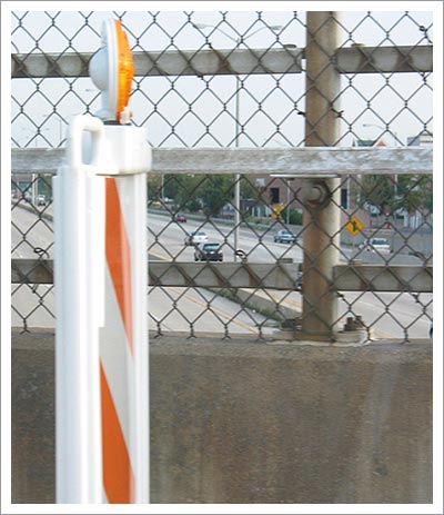
Fig2. A view of the Edens from Lake Cook Road.
Chicago Traffic Resources on the Web
General Resources
Chicago Department of Transportation. This site includes information on local highway construction projects and information on other projects such as sidewalk repair, street resurfacing and pothole repair.
Gary-Chicago-Milwaukee Travel Website. The award-winning GCM Travel Website is a cooperative effort from the Illinois Department of Transportation, Indiana Department of Transportation, Wisconsin Department of Transportation, and Federal Highway Administration. The site includes real time maps of traffic congestion and construction closures, detailed travel time information for all major expressways and tollways, and links to additional traffic resources.
Illinois Department of Transportation. Get the latest news on construction and other Illinois highway projects. Find out the average daily traffic volumes for Illinois roadways, order a free Illinois highway map and much, much more.
Illinois State Toll Highway Authority. The official source for the latest news concerning Illinois tollways. Order an I-Pass online. Find out how many oases are located over Illinois tollways.
Weather-Related Resources
Icepack.org. "Icepack is a coalition of non-profit and private agencies in Illinois and Indiana dedicated to saving motorists lives by preparing them for the hazards associated with winter driving." The site includes information about traffic and road conditions, winter driving tips, and a handy checklist for winterizing your car.
Illinois Weather. Get detailed hourly weather reports for areas around the state straight from the National Weather Service. Includes satellite and radar maps, plus up-to-date information on weather warnings and advisories.
Just For Fun
Illinois Highways Page. Owned and maintained by Rich Carlson, a suburban Chicago police officer, this site contains more information than you could ever possibly want to know about the Illinois Numbered Highways System. Includes photos, history, trivia and an email discussion group. Almost scary in its comprehensiveness but also great fun.
