Gapers Block has ceased publication.

Gapers Block published from April 22, 2003 to Jan. 1, 2016. The site will remain up in archive form. Please visit Third Coast Review, a new site by several GB alumni.
 Thank you for your readership and contributions. 

TODAY

Saturday, April 20

Gapers Block
Search

Gapers Block on Facebook Gapers Block on Flickr Gapers Block on Twitter The Gapers Block Tumblr


The Mechanics
« Mayor Emanuel Should Learn from His Predecessor's Mistakes Q & A with Political Writer Tariq Ali »

Public Transportation Thu Oct 06 2011

Transit 2020: An Immodest Proposal For the CTA

by John Fitzgerald and Ramsin Canon


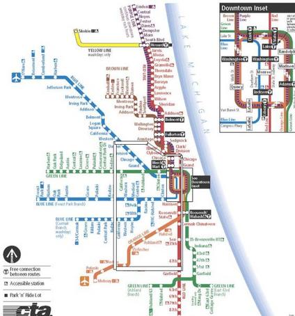
View Chicago Rail Transit in a larger map

Outside of the persistent problem of slack capital spending, Chicago rapid transit currently suffers from two major physical problems. The El leaves a large portion of the city underserved or wholly unserved. Also, the El is too "loop-centric", making travel between different non-loop areas slow and time consuming. This is in part a legacy of the system's origins. Privately owned and operated until 1947, rail operators insisted that their charters include service to the central business district to ensure profitability. Neighborhood-to-neighborhood service on its own was not profitable enough for the securities holders who regularly flexed their political power to protect their charters.

Our proposal here seeks to address redundancy and coverage issues by creating three new train lines in the city and reorganizing the current system.

These new lines will consist of:
a) a train along Kedzie Avenue, from Evergreen Plaza to Lincolnwood Town Center ("K Train" or "Black Line"),
b) an Outer Loop train, running downtown to 49th Street, along the viaduct at 49th, north on Kedzie, along the Bloomingdale viaduct, and back downtown ("White Line"), and
c) the incorporation of the Metra Electric South Shore line into a fully integrated CTA line ("Gold Line").

A smart reorganization of intermodal and intersystem operations would improve efficiency and close gaps in the current system. These will be discussed later, along with some reasonable but ballparky cost and economic estimates.

North - South Travel

North-south travel away from the Lake is tedious. With no train service, outside of long and inefficient trips all the way downtown and then a transfer back out, the back bone of service is slow moving buses on crowded city streets. The Black Line Kedzie Train, or K Train, would change all of this. The K train would start at Evergreen Plaza, and run from 95th Street and Kedzie Avenue as a subway north to Lincolnwood Town Center, on Touhy (possibly emerging here at ground level). The K train would run for approximately 21 miles, with 25 stops. An access tunnel around Kedzie and Eastwood would link the Black Line CTA rail yard at Kimball.

Connections with the existing train lines would provide much needed flexibility to the transit system and added benefits to Chicagoans. The K train would connect to:

• The Metra, at 79th and Kedzie
• The existing Orange Line, at 49th Kedzie (more on this later)
• The Blue Line, at the Eisenhower and again at Logan Square
• The Brown Line, at Kedzie and Eastwood
• The Green Line, at Kedzie and Lake
• The Pink Line, at Kedzie and Cermak

In addition the Black Line (K Train) would share approximately 8 miles with White Line (Outer Loop train), from 49th to Bloomingdale. We could test your patience and list the dozens of neighborhoods this would service, but that is the purpose of maps.

Black Line.jpg

Outer Loop Train

The aforementioned White Line (Outer Loop) train would provide cross town connectivity; it would be essential to making the Black Line or K Train functional and useful. North-south travel is difficult away from the lake, but east-west travel at latitudes further from the Loop also requires too much redundancy: rather than a straight line, travelers have to make parabolic trips to go from point point a (west) to point b (east).

This line would allow travelers to travel east-west or north-south to either get to their destination or transfer to other lines. By using existing (or planned) El lines, costs for development of this system would be minimal. The train would start downtown (as much as a loop can start somewhere) and would make all Red Line stops from North and Clybourn to 47th St. It would transfer over to the existing viaduct just south of 49th Street. To connect the Dan Ryan and 49th St. viaduct portion, new tracks would be built, either as a subway under the Dan Ryan, or, more likely, tracks over the highway, a la the Green Line at 63rd or the Blue Line at Paulina.

The White Line would run along 49th St. viaduct, sharing stations with re-done Brown Line (see below) at the Western and Kedzie stops, and then head north along Black Line trunk subway. The White Line would continue to Bloomingdale Ave., and rise onto existing viaduct along Bloomingdale. It would share most stops long this route with Black Line. This Outer Loop train would run along Bloomingdale to Ashland, and then become subway, heading southeast to Elston and North Stop, under North Ave. to North and Clybourn, and thence onto Red Line. The route would cover 31 stops over 24 miles. In addition to all of the stops the White Line would share with Black and Red Lines, this train would connect to:

• The existing Orange Line, at 49th Kedzie and 49th and Western
• The Blue Line, at the Eisenhower and Kedzie, and at Western
• The Green Line, at Kedzie and Lake
• The Metra, at Clybourn
• The Pink Line, at Kedzie and Cermak

The only portions of this train that would be totally new would be the track connecting the east-west sections to the north-south sections, though significant portions of dilapidated viaduct would need to retracked and rehabilitated. More importantly, this train would facilitate east-west travel in underserved neighborhoods, providing crucial links between Humboldt Park and, especially, Back of the Yards with the rest of the city.
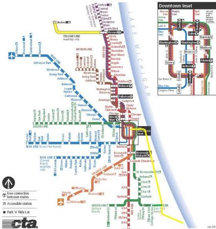
Again: Maps!!

White Line.jpg

Gold Line, Or South Shore

Essential for fluid intermodality and making the system more comprehensive is the Gold Line or South Shore train. The Gold Line would run along existing Metra Electric South Shore tracks. This was proposed by Southsiders Organizing for Unity and Liberation (SOUL). There would be twenty one stops along the existing Metra Electric South Shore Line, including a stop directly underneath McCormick Place and another just steps from Soldier Field, which is currently terribly under served by public transportation. At the Millennium Station, the train would turn west and a run as a subway to a final stop at Washington and State, connecting with the Red Line (and to Washington/Dearborn Blue Line). This train would provide links from Hyde Park and South Shore to the rest of the city, not just to downtown during business hours. This would be a boon to main Hyde Park shopping districts, and a sorely needed means of access to Hyde Park and downtown for residents of these neighborhoods who, without a car, are cut-off from the rest of the city.

The Gold Line would connect with the Green Line (see the proposed extension below) at 63rd Street, and the Red and Blue Lines at Washington and State. (While Washington is no longer a stop on the Red Line, the platform still exists there. We do not know what the extent of construction was on the Blue/Red connecting tunnel during Lot 37 construction, but, regardless, we don't see any reason for this to pose any serious issues.)

Hey, guess what? Maps!

Gold Line and Greenline Extension.jpg

Existing Lines

A second aspect of the plan would be a small reorganization of the system's existing lines. First, there is no reason that the Orange and Brown Lines should be different lines. Combining them (we told you we'd get to this!) would create seamlessness, no additional track construction, a line that is both expansive and geographically logical and easier access to Midway Airport. When downtown the new Brown Line would run on the South and East sides of the Loop. This would ease congestion in the loop, with South/West loop running 3 trains during rush hours, down from 4, and North/East loop running 3 trains instead of 5.

To facilitate this new route a Clark and Lake style Superstation would be built at Jackson. It would connect the El stop at Library with Jackson/ Dearborn Subway (Blue Line) and Jackson/State Subway (Red/White Lines). There would be a free transfer to the Adams/Wabash station. Including this free transfer, the Jackson Superstation would connect the Red, Green, Brown, White, Blue, Purple, and Pink Lines. As the new Brown Line would no longer stop at Clark and Lake, a free transfer would be available between Clark and Lake and Washington/Wells.

In several other locations, the El passes near important locations without stopping. For one, a Green Line stop at Cermak would be mere blocks from McCormick Place, one of the region's most important economic engines, and in the midst of a neighborhood slated for significant development. Also, the Green and Pink lines pass within a few blocks of the United Center. A Madison Street stop on these two lines would be added. And maybe most ridiculously, the Blue Line stops a couple of blocks from, but does not connect to, Union Station, at Clinton. As such, the Clinton Blue Line stop would be expanded and connected underground to Union Station, allowing seamless travel between O'Hare Airport and Union Station.

Of course, station upgrades would need to take place where new lines meet old lines, to facilitate transfer between the different lines. Be it elevated-to-elevated transfer, like at Western and Armitage where the Blue Line would meet the White Line, elevated-to-subway, such as at Kedzie and Lake, where the Black/White Lines meet the Green Line, or subway-to-subway transfer, as at Logan Sqaure, confluence of the Black and Blue Lines, these stations would be crucial, but would be constructed at the same time as the new lines.

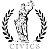
The last, tiny piece would be an extension of the 63rd/Cottage Grove branch of the green line, to Stony Island. This would bring it to one of the major South Side thoroughfares, as well as the new Gold Line and the Metra. The extension would be about 2/3 of a mile, with only this one new stop.

The Cost - Not So Bad

We had to search to come up with a basis for my estimates. As we mentioned before, these are fairly ballparkish, so we tended to round up. We are open to experts weighing in. But here we go:

We have 21 miles of subway from Evergreen Park to Lincolnwood Town Center--according to this guy, subway would cost $141mn per km. We just use $150mn, so 21 miles = 35 km X $150mm= $5.25 billion plus one mile of subway from Ashland and Bloomingdale to North and Clybourn, so +$250mm equals $5.5B.

Plus 6 miles of track on existing viaducts and right of ways:
• 4 from Dan Ryan to Kedzie and 49th, and,
• 2 from Kedzie and Bloomingdale, to Ashland and Bloomingdale.

Wikipedia sets the base light rail cost at $35mn per mile, but there is a high degree of variability (from $20mn/mi in Baltimore to $179mn/mi for tunnels in Seattle). This won't technically be light rail, but it will also be existing track and stations on portions of the existing Orange Line. And it will all be on existing viaducts. So, we took the base, and added an amount equal to the difference of the base and more inexpensive systems (once again $20mn/mi), or $50mn/mi. So 6 x $50mn = $300 mn.

The Gold Line was estimated at $160mn. The addition of Washington and State would be 0.3mi (.5km) to Millennium Station (so $150mn/km= $75mn). So $160mn + $75mn= $235mn.

For the Green Line one mile extension, we had no great estimates, so assumed 0.5 cost of subway, or $125mn.

This cost does not include new stations, at Madison/United Center and Cermak/McCormick Place. The new Morgan Street on the Green and Pink Lines costs $38mn (per the CTA Morgan Street Station), so multiplied by two is approximately $80mn. And the same cost for Western Station extension, on the Blue Line (to connect with White Line "Outer Loop"). So approximately $120mn.

So far we are at, in billions:
$5.5 + $0.300 + $0.235+ $0.125 + $0.120= $6.28bn

As we could not find good estimate bases, we leave out upgrades to the Jackson Superstation and the Clinton Station expansion to Union Station. We also leave out the connections between elevated and subway, grade level and subway, and subway to subway stations listed above. The cost of line construction generally includes station construction, but these connections go above and beyond that.

So the overall cost would be about $6.3bn, excluding a few stations. A pretty penny. But former Chair of the White House Council of Economic Advisors Chrstina Romer, in her paper on the Recovery Act, assumed a multiplier effect of 1.57x on direct government spending. So this would increase GDP by $9.86bn.

What About Buses?

Don't get us wrong. Buses are awesome. But they are not very efficient, and they currently carry too much of the load, particularly for travel away from the Lakefront. This, too, is partially a legacy of the city's privatized system. The public waged a forty year fight, from 1907 to 1947, to make public the city's expansive streetcar system. (The campaign was called "IMO" in shorthand for the catchy slogan "Immediate Municipalization now!") The securities holders fought to keep the system private and, when municipalization seemed like a fait accompli in the 1930s, used legal and political tactics--including bribery--to gouge the city for a huge payment despite the system's crumbling physical condition.

When it was finally municipalized in 1947, streetcars were on the way out as the end of World War II saw an explosion in car ownership and sharp decreases in urban density, particularly in Chicago where white flight hollowed the city's working class neighborhoods. Eight years later, the Chicago Motorcoach Corporation, the private operator of the city's buses, was municipalized and the streetcars were torn out or paved over. The public ended up paying securities holders enormous sums for a system that disappeared within eight years.

Obviously, streetcars are not coming back any time soon. The cost would be prohibitive and Chicago's car-friendly design would suffer disruption that would make the Big Dig look like street cleaning. There is another option of course: Bus Rapid Transit (BRT).

The Metropolitan Planning Council (MPC) has studied the feasibility of BRT in Chicago. The MPC study found that the city could sustain ten BRT routes, totaling ninety-eight miles at a cost of about $13mn per mile, for a rough total of $1.3bn (the total is our estimate).

Totally worth it: bus rapid transit significantly decreases bus travel times, is ideal for intermediate-distance trips (between one and three miles) and helps clear congestion for cars and bicycles. A BRT system in conjunction with our Immodest Proposal would make intra-neighborhood movement extremely fluid, minimizing congestion and encouraging density.

In Summation

Chicago's challenge is that it is geographically huge--almost five times the size of Boston, only about sixty square miles smaller than all five boroughs of New York--but not particularly dense. It is hard therefore to justify heavy rail in particular because initially at least there would not be the demand to travel from, for example, Heart of Chicago to Albany Park. However, ease of movement between these neighborhoods and better integration of lines would encourage density, particularly if the heavy rail system were phased in along with BRT. As commute times between neighborhoods and the Loop, neighborhoods one with another, and neighborhoods and other modes of travel--such as Metra and Pace--decreased, the livability of once-isolated neighborhoods would appreciate and increased transit capacity would generate its own demand.

But first and foremost, more people need to have access to rapid rail transit in the city of Chicago. People on the South Shore, Southeast and in Hyde Park would immediately have increased access to the rest of the city. Movement into, out of, and around sections of the South and West and North Sides would likewise be greatly improved. Also, we would finally move away from the completely Loop-centric transit system that is inefficient and inhibits development in large swaths of the city. The planned Circle Line starts this, but this proposal solidifies it. Additionally, in this time of high unemployment, we could inject almost $10bn into the city economy, and the federal government would see as much twenty-five percent of its investment returned directly in taxes.

As a system like this was phased in, congestion pricing for the Loop and market pricing for parking (see this exhaustive report on parking policy on GB) would become more feasible, since credible and efficient options for transportation would finally exist. With fewer cars on the road, streets could be made more amenable to bicyclists, which would reduce congestion even more and make our streets safer, potentially saving millions in health care and lost efficiency associated with high-congestion surface streets.

Daniel Burnham instructed us a century ago to "make no little plans." What most people don't know is that this was a typographical error; having grown rotund in his advanced years and furious at his tailor, what he actually said was "make no little pants." Actually, we just made that up.

Nevertheless, our point is not diminished: Chicago needs a big vision for a transit system spinning its wheels in the muck of mid-twentieth century urban planning. Small fixes here and there, implemented piecemeal, will never accumulate to the point that the basic infrastructural problems of the system will just disappear.

John Fitzgerald is a former union organizer and financial analyst, making him a freak. He has a firm grasp of basic arithmetic and loves his country. He has lived in Chicago for 8 years.

Ramsin Canon is the politics editor of GapersBlock.com. He has lived in Chicago longer than John Fitzgerald.

 
GB store

Greg / October 5, 2011 3:26 PM

Perhaps you intended to limit the scope of discussion to Chicago's borders, but why terminate the K Train at Lincolnwood Town Center and not extend it another mile or so to the Yellow (maybe at Dodge, which is apparently under consideration as a stop anyway)? This would provide the K and all its connecting lines with another artery to the Skokie Shops on Oakton.

Nick / October 5, 2011 3:54 PM

Interesting proposal. Definitely seems more useful than the Circle Line, especially when it comes to the south and west sides.

Agree with Greg on the Yellow Line connection. Apparently Kimball Yard can barely service Brown Line traffic yet alone a major trunk route.

Many have previously suggested combining the Brown and Orange Lines before, but how would the differing ridership be handled? You'd either have too much service on the Orange portion or too little on the Brown. Adding extra Purple Line trains in lieu of Brown would only help those south of Belmont. You'd need to have certain trains from Kimball head back north at the Loop or do something like what the CTA proposed for the Circle Line: also combine the Pink and Brown Lines.

John / October 5, 2011 5:12 PM

Greg, good point on extending it to the yellow. I originally envisioned linking the yellow there, but that got lost in the mix. My bad.

Nick, the point about travels loads is a good one, but you could run more trains if you cut down on congestion in the loop. Part of the idea is to give more people access to Midway airport, which slightly trumps giving more people access to Nuevo Leon. Slightly.

Chris / October 5, 2011 5:43 PM

The CTA should also extend the Brown Line along Lawrence to Jefferson Park and the Blue Line, improving access to O'Hare from the North Side.

Streetcars shouldn't be ruled out. They could fit in nicely along Michigan Avenue or Roosevelt Road for shorter distances. Portland and now Washington, D.C., has shown how they can work and serve a different function than mere buses. Streetcars and electric buses like those in Seattle and San Francisco operate on a much more efficient electric motor powered by overhead lines. Far more durable than diesel buses that dump exhaust pollution directly into the city.

It should be noted that Chicago had many miles of both streetcars and electric buses up until the late 50s and 60s. And it shouldn't be viewed as a fait accompli that these modes of transit were obsolete; that's the spin that was offered by General Motors who played a strong hand in Richard J. Daley's decision to rip them all out in the name of progress. Huge mistake.

Otherwise, these ideas are great. But the CTA still needs to focus first on a complete overhaul and extension of the Red Line, the system's lifeblood, from Howard Street to 95th and soon 130th Street.

Johnr / October 5, 2011 5:53 PM

You go a half mile east and you can use the whole existing western avenue freight corridor, all existing track, at a cost of 35 million/mile.

Brings the cost of this project down to under a billion and much more realistic.

This has been posed to the CTA before, but they always find some excuse to say they need their own dedicated track.

Eli / October 5, 2011 6:01 PM

Either the White Line needs to be extended north, or there needs to be a better connection between the Red Line and the Black Line on the north side. There is a ton of density all along the north side lakefront Red Line (far-north Edgewater and Rogers Park have some of the highest population densities in the city), but those of us who live there have basically no option for getting to the southwest, west, or northwest sides except buses or traveling into and then out from the loop--and this plan does nothing to improve that.

Joe / October 5, 2011 7:28 PM

This is a great idea, but I think that the circle/White Line would almost certainly need to find a new East/West line in the north since the Bloomingdale Trail park and bike path becomes more a reality every day: http://www.cityofchicago.org/city/en/depts/dcd/provdrs/sustain/news/2011/oct/new_park_would_offergreenspaceaccesstofuturetrail.html; http://featuresblogs.chicagotribune.com/theskyline/2011/10/for-years-park-advocates-have-dreamed-of-turning-a-dormant-railroad-line-on-chicagos-northwest-side-into-an-elevated-linear.html.

Also, it concerns me that the South Side would still miss out on some of the benefits, as the proposed White Line would not connect to either the Gold Line or the Green Line on the South Side. I think that rather than use the Red Line, the White Line could use the same tracks as the Gold Line and go through the same connection at State & Washington where you believe the Gold Line would end. Then the White Line would have to cut across a longer portion of the South Side and would connect the South Sides lines. Just a thought.

hj / October 5, 2011 8:41 PM

There are lots of problems I see here in your plan, numerous areas with clumsy connections, repetitive rail patterns and choosing investment in lower density areas that are a bit too remote right now to warrant huge infrastructure costs. If you want to do a Kedzie Avenue line then you desperately need a filler line to service the areas between the CBD and out West.

Neighborhoods like Bucktown, Wicker Park, East Village, Noble Square, Pilsen and Bridgeport are all much more equipped (density wise) and deserving (desirability) of a line. IMO the first "connector line" that should be built would utilize Ashland, where it would run through these neighborhoods, intersecting existing stations such as the Division Blue, Ashland/Lake Green and Pink, IMD Blue and the Ashland Orange.

A Kedzie subway line should be targeted as a phase 2 connector, started once the Ashland line is completed (phasing outward growth to mimic real estate build out)

A fellow Gapers Block writer did a good job years ago coming up with an ambitious CTA plan, CTA 2055 http://www.gapersblock.com/detour/a_cta_map_for_2055/ , in which he raised many good ideas and options, although some are quite unreasonable (Roscoe Subway, North Central Line and the Green Line Loop) But I feel that the majority is sound and his reasoning fairly agreeable.

Patrick / October 6, 2011 5:54 AM

move that black line a little north, and you got a deal. i literally work right on the corner of 95th and kedzie and would want no part of all of that traffic caused by this line. plus, it's be pretty hard to put the end of a line there, with all of the work being done on the intersection already. I'd say take the end of the line north by one mile to 87th and Kedzie. that intersection would be more suited to heavy traffic. more space for parking and mobility to get into the station if it were underground.

Anne / October 6, 2011 4:09 PM

It would be tricky to add a terminal at 95th & Kedzie, however, it could make a big difference in REDUCING 95th St. traffic, because it would provide access to 95th St. businesses.

Nate Whilk / October 6, 2011 6:40 PM

"Immodest"? The denial in this proposal is breathtaking. THERE IS NO MONEY AVAILABLE. Chicago and Illinois could very well go bankrupt before 2020, and the Fed is in a huge hole as well.

We need to concentrate on how to get through the next 10 years, not propose huge new spending and taxes.

This plan is simply insane.

Eric M / October 7, 2011 12:39 AM

Based on the CTA's own cost estimates for similar projects, your estimates are wildly, optimistically, low. You have at least two base estimates from the CTA to consider: the Circle Line subway estimates, and the north Red Line replacement subway cost estimate. You also don't try to account for property aquisition, which even for subways adds up (station houses, etc).

The Toronto number you use is 10-15 years old. It also is only the cost of the tunnel creation, and doesn't include the cost of stations.

Altogether, using the CTA's own cost estimates, a better estimate for subway costs is about $200 million per mile of tunnel plus $100 million per station. Those costs are for main-line costs. Stations that join other lines will cost more (maybe even more than twice as much).

Also, considering the CTA spent nearly $200 million just joining the Blue and Red under Block 37, your estimate for turning the "Gold Line" west is far too low.

A more honest estimate of for the cost of your project would be closer to this (I'm sort of guessing at the number of stations you're advocating):

22 miles subway tunnels:
$4.4 billion

6 miles elevated rail on existing ROW:
$600 million

1 mile Green "L" extension:
$100 million

3 superstations (built in existing complex, high-density areas):
$750 million

28 subway stations:
$2.8 billion

10 elevated stations:
$250 million (lower than the Clinton station, because most would be on new lines, not built on in-use lines)

Grey Line:
$175 million

Grand total:
$9.075 billion

This doesn't account for additional cost for subway/surface portals, nor additional cost for transfer stations.

It also doesn't at all address the cost of new rolling stock. This is basically close to a 20% increase in capacity, however, so the CTA would likely need 20% more rail cars. They have about 1000 now, so 200 more at about $1.7 million each, so add in another $340 million for those.

And then there's operating costs. Even if the new lines generated revenue at the same rate as the system at large does now (which I personally doubt, but we'll go with it), a 20% increase in capacity would likely increase operational costs by a minimum of $250 million/year. If half that came from fares, that still leaves $125 million per year in public funding to identify.

Gary / October 7, 2011 12:35 PM

How about using an up to date cta map with the new logo and has pink line?

John / October 7, 2011 4:02 PM

Eric M:

Good work, and thank you. Could you provide some links?

Jake / October 8, 2011 1:46 PM

Why couldn't streetcars be re-introduced in Chicago? Of course it would interrupt Chicago's car-centric culture (in some areas) but that's a GOOD thing. Cities are not and should not be made strictly for the convenience of automobiles. I think it's a shame that a city that once had the largest and most expansive streetcar system in the world can't muster up the courage to do it again.

You talk about Chicago's density being too little in many areas to justify heavy rail, at least for the time being. I agree with you, especially in areas on the Southside. But those are areas PERFECT for streetcar use. Streetcars could build up density that, in turn, could justify later heavy rail additions to the areas. It increases mobility sooo much. A few streetcar lines strategically placed around the city could increase mobility a ton.

I'm new to Chicago so I'm sure someone could provide a much better example but I'll give it a shot. Take Logan Square and the surrounding area. A bit far from the El. A streetcar line connecting say, the California El stop, through Logan Square, and then connecting to the Healy Metra station could be useful. Or how about a streetcar line from the Green Line connecting to the University of Chicago. I remember trying to get to UofC when I was doing college visits was a nightmare. A streetcar could really help and provide more economic development than any bus project would.

Once again, I'm new to the area so my examples probably aren't very good. I'm still getting familiarized.

Thank you. Have a great day!

Jake / October 8, 2011 1:50 PM

Yeah I just looked up the distance for that Logan Square thing I was talking about. Haha DEFINITELY not a good example. My apologies.

Gordon / October 10, 2011 2:54 PM

Great stuff, love these sorts of posts (much as I agree with a few above critiques and that sadly the cost estimates are low). Anyway, for sake of discussion and self promotion, here's a neat Gold Line map with stations that I created for the Southside advocacy group SOUL a couple of years ago during the pre-olympic wrangling about that idea...
http://home.uchicago.edu/~gdouglas/GoldLineMap.jpg

Mike Payne / October 12, 2011 2:08 AM

The "Gold Line" is a partial implementation of the original "CTA Gray Line" Proposal:

http://bit.ly/GrayLineInfo

Jeff / October 12, 2011 8:22 AM

What garbage!
First, as pointed out earlier, you end your Kedzie line 1.5 miles from the Yellow Line. The correct street for a north south subway would be Western, not Kedzie. It's a wide street so you could build a four track tunnel there & run express trains.
Then you want to rebuild the Green Line east to Stony Island, when it was removed years ago & made the Woodlawn community happy with that removal.
This does nothing to give better connections between Union & Northwestern Stations except for your long, long tunnel from Congress St. to Union.
What's needed is the Super Loop.
Move the Wells St portion of the Loop L to Clinton St & there will then be direct connections to the L.
And you can't connect the Brown & Orange Lines due to a massive disparity in ridership. Brown has almost twice the riders of Orange. You want a balanced system so you can allocate rolling stock properly.

Dave / October 12, 2011 2:03 PM

$141M per km is a very lowball estimate for a subway. Other countries get to pawn off the costs of medical coverage for their construction workers to the national government, but in privately-insured America, the subway contractors would have to pass along that cost as part of general "labor" costs. Medical coverage for any employee adds 20-30% to their nominal salaries... for construction workers with a higher likelihood of injury, that coverage could be more.

Also, in litigious America, an avalanche of lawsuits could be expected from all business owners who happen to be inconvenienced and/or lose sales along Kedzie and other corridors during construction. The subway also might face environmental lawsuits and/or require the removal and replacement of existing underground utilities. The $141M doesn't seem to anticipate those legal costs.

sergio / October 13, 2011 6:06 AM

OK. Am I the only one here who things this is a terrible plan? (except for Jeff)
The only good portion of this plan is the Gold line. And what Chicago really needs is a full length LAKE SHORE LINE. Have you seen Lake Shore commute? Have you seen the lake shore buses how PACKED they are? Have you seen how many people take those buses on Michigan Ave rather than walk two extra blocks to the Red line? Chicago needs a line parallel to the RED but closer to the lake front. It will NOT be redundant.
Also... with your plan I still can't get to NAVY PIER (huge tourist attaction), Lincoln Park Zoo (another HUGE attraction), The Beaches, NORTHWESTERN memorial (huge employer!), Ogilvie or UNION STATION!
So where exactly does this plan take me? Oh yeah... KEDZIE and south 49th street!
Union station and Ogilvie need to be fully incorporated to the EL. The few connections your plan makes are not a good substitute.
The best proposals out there are the circle line (much hated I know), the west loop transportation center, and the clinton street subway/whatever.
What you also need is lines with combined express local trains. It takes waaaaaay too much time to make long distance trips on the EL because of all the stops!

Finally. Let me give you an example.
I was recently working in Chicago. I was staying in the gold coast (not that close to the red line though).
I was working in Oak Brook. I wanted to commute by public transport since the traffic on the 290 is notoriously horrible.
So google advised the following:
Take the 151 but (YES THE slow every-two-block stop and go 151 bus) to Union station and then the Metra.
REALLY? That right there was a non-starter. Then I said... well, let me take the red line. But the walking-transfers are a deterrent! I want to take ONE train (OK, maybe two) that takes me DIRECTLY INTO UNION station and then the metra.

I guess I'll be waiting for that for a long time.

But no worries. I live in NYC (though I love Chicago).

Jeff / October 13, 2011 2:21 PM

While I like that you agree with me that this plan is garbage, an additional line near the lake is unnecessary.
What I would have done is move the subway from State St between Lake St & Clark/Division to Michigan Ave. That's where the people & businesses are. Then the abandoned subway could be held in reserve for winter storage during blizzards or other problems. But they went & spent hundreds of millions on rebuilding the Grand & Chicago stations. A total waste! The other north south street that needs a line is Cicero, but it should start at Howard, follow the Swift tracks west & then use the abandoned Mayfair Cutoff & Cragin Lines of the C&NW south to the Belt Ry to Midway & Ford City & then east on the Pennsylvania ROW around 76th to the Dan Ryan Line.

Myron Lee / June 1, 2015 3:18 PM

I like your initiative, a couple ideas to help get thousands to O'hare with the train and help reduce all the traffic (taxis) congestion at the airport. Have the K intersect the yellow line at Skokie and then join Skokie to O'Hare. Or shift K line over to Cicero for the North/South corridor all the way up to Skokie and then extend the Brown line all the way west to the Blue line

GB store

Feature

Parents Still Steaming, but About More Than Just Boilers

By Phil Huckelberry / 2 Comments

It's now been 11 days since the carbon monoxide leak which sent over 80 Prussing Elementary School students and staff to the hospital. While officials from Chicago Public Schools have partially answered some questions, and CPS CEO Forrest Claypool has informed that he will be visiting the school to field more questions on Nov. 16, many parents remain irate at the CPS response to date. More...

Civics

Substance, Not Style, the Source of Rahm's Woes

By Ramsin Canon / 2 Comments

It's not surprising that some of Mayor Emanuel's sympathizers and supporters are confusing people's substantive disputes with the mayor as the effect of poor marketing on his part. It's exactly this insular worldview that has gotten the mayor in hot... More...

Special Series

Classroom Mechanics Oral History Project
GB store


About Mechanics

Mechanics is the politics section of Gapers Block, reflecting the diversity of viewpoints and beliefs of Chicagoans and Illinoisans. More...
Please see our submission guidelines.

Editor: Mike Ewing, mike@gapersblock.com
Mechanics staff inbox: mechanics@gapersblock.com

Archives


 Subscribe in a reader.

GB store

GB Store

GB Buttons $1.50

GB T-Shirt $12

I ✶ Chi T-Shirts $15