| « Mayor Emanuel Should Learn from His Predecessor's Mistakes | Q & A with Political Writer Tariq Ali » |
Public Transportation Thu Oct 06 2011
Transit 2020: An Immodest Proposal For the CTA
by John Fitzgerald and Ramsin Canon
View Chicago Rail Transit in a larger map
Outside of the persistent problem of slack capital spending, Chicago rapid transit currently suffers from two major physical problems. The El leaves a large portion of the city underserved or wholly unserved. Also, the El is too "loop-centric", making travel between different non-loop areas slow and time consuming. This is in part a legacy of the system's origins. Privately owned and operated until 1947, rail operators insisted that their charters include service to the central business district to ensure profitability. Neighborhood-to-neighborhood service on its own was not profitable enough for the securities holders who regularly flexed their political power to protect their charters.
Our proposal here seeks to address redundancy and coverage issues by creating three new train lines in the city and reorganizing the current system.
These new lines will consist of:
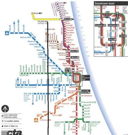
a) a train along Kedzie Avenue, from Evergreen Plaza to Lincolnwood Town Center ("K Train" or "Black Line"),
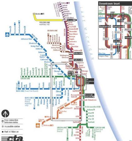
b) an Outer Loop train, running downtown to 49th Street, along the viaduct at 49th, north on Kedzie, along the Bloomingdale viaduct, and back downtown ("White Line"), and
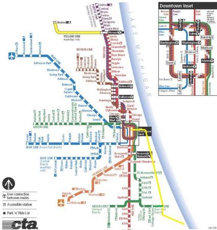
c) the incorporation of the Metra Electric South Shore line into a fully integrated CTA line ("Gold Line").
A smart reorganization of intermodal and intersystem operations would improve efficiency and close gaps in the current system. These will be discussed later, along with some reasonable but ballparky cost and economic estimates.
North - South Travel
North-south travel away from the Lake is tedious. With no train service, outside of long and inefficient trips all the way downtown and then a transfer back out, the back bone of service is slow moving buses on crowded city streets. The Black Line Kedzie Train, or K Train, would change all of this. The K train would start at Evergreen Plaza, and run from 95th Street and Kedzie Avenue as a subway north to Lincolnwood Town Center, on Touhy (possibly emerging here at ground level). The K train would run for approximately 21 miles, with 25 stops. An access tunnel around Kedzie and Eastwood would link the Black Line CTA rail yard at Kimball.
Connections with the existing train lines would provide much needed flexibility to the transit system and added benefits to Chicagoans. The K train would connect to:
• The Metra, at 79th and Kedzie
• The existing Orange Line, at 49th Kedzie (more on this later)
• The Blue Line, at the Eisenhower and again at Logan Square
• The Brown Line, at Kedzie and Eastwood
• The Green Line, at Kedzie and Lake
• The Pink Line, at Kedzie and Cermak
In addition the Black Line (K Train) would share approximately 8 miles with White Line (Outer Loop train), from 49th to Bloomingdale. We could test your patience and list the dozens of neighborhoods this would service, but that is the purpose of maps.
Outer Loop Train
The aforementioned White Line (Outer Loop) train would provide cross town connectivity; it would be essential to making the Black Line or K Train functional and useful. North-south travel is difficult away from the lake, but east-west travel at latitudes further from the Loop also requires too much redundancy: rather than a straight line, travelers have to make parabolic trips to go from point point a (west) to point b (east).
This line would allow travelers to travel east-west or north-south to either get to their destination or transfer to other lines. By using existing (or planned) El lines, costs for development of this system would be minimal. The train would start downtown (as much as a loop can start somewhere) and would make all Red Line stops from North and Clybourn to 47th St. It would transfer over to the existing viaduct just south of 49th Street. To connect the Dan Ryan and 49th St. viaduct portion, new tracks would be built, either as a subway under the Dan Ryan, or, more likely, tracks over the highway, a la the Green Line at 63rd or the Blue Line at Paulina.
The White Line would run along 49th St. viaduct, sharing stations with re-done Brown Line (see below) at the Western and Kedzie stops, and then head north along Black Line trunk subway. The White Line would continue to Bloomingdale Ave., and rise onto existing viaduct along Bloomingdale. It would share most stops long this route with Black Line. This Outer Loop train would run along Bloomingdale to Ashland, and then become subway, heading southeast to Elston and North Stop, under North Ave. to North and Clybourn, and thence onto Red Line. The route would cover 31 stops over 24 miles. In addition to all of the stops the White Line would share with Black and Red Lines, this train would connect to:
• The existing Orange Line, at 49th Kedzie and 49th and Western
• The Blue Line, at the Eisenhower and Kedzie, and at Western
• The Green Line, at Kedzie and Lake
• The Metra, at Clybourn
• The Pink Line, at Kedzie and Cermak
The only portions of this train that would be totally new would be the track connecting the east-west sections to the north-south sections, though significant portions of dilapidated viaduct would need to retracked and rehabilitated. More importantly, this train would facilitate east-west travel in underserved neighborhoods, providing crucial links between Humboldt Park and, especially, Back of the Yards with the rest of the city.
Again: Maps!!
Gold Line, Or South Shore
Essential for fluid intermodality and making the system more comprehensive is the Gold Line or South Shore train. The Gold Line would run along existing Metra Electric South Shore tracks. This was proposed by Southsiders Organizing for Unity and Liberation (SOUL). There would be twenty one stops along the existing Metra Electric South Shore Line, including a stop directly underneath McCormick Place and another just steps from Soldier Field, which is currently terribly under served by public transportation. At the Millennium Station, the train would turn west and a run as a subway to a final stop at Washington and State, connecting with the Red Line (and to Washington/Dearborn Blue Line). This train would provide links from Hyde Park and South Shore to the rest of the city, not just to downtown during business hours. This would be a boon to main Hyde Park shopping districts, and a sorely needed means of access to Hyde Park and downtown for residents of these neighborhoods who, without a car, are cut-off from the rest of the city.
The Gold Line would connect with the Green Line (see the proposed extension below) at 63rd Street, and the Red and Blue Lines at Washington and State. (While Washington is no longer a stop on the Red Line, the platform still exists there. We do not know what the extent of construction was on the Blue/Red connecting tunnel during Lot 37 construction, but, regardless, we don't see any reason for this to pose any serious issues.)
Hey, guess what? Maps!
Existing Lines
A second aspect of the plan would be a small reorganization of the system's existing lines. First, there is no reason that the Orange and Brown Lines should be different lines. Combining them (we told you we'd get to this!) would create seamlessness, no additional track construction, a line that is both expansive and geographically logical and easier access to Midway Airport. When downtown the new Brown Line would run on the South and East sides of the Loop. This would ease congestion in the loop, with South/West loop running 3 trains during rush hours, down from 4, and North/East loop running 3 trains instead of 5.
To facilitate this new route a Clark and Lake style Superstation would be built at Jackson. It would connect the El stop at Library with Jackson/ Dearborn Subway (Blue Line) and Jackson/State Subway (Red/White Lines). There would be a free transfer to the Adams/Wabash station. Including this free transfer, the Jackson Superstation would connect the Red, Green, Brown, White, Blue, Purple, and Pink Lines. As the new Brown Line would no longer stop at Clark and Lake, a free transfer would be available between Clark and Lake and Washington/Wells.
In several other locations, the El passes near important locations without stopping. For one, a Green Line stop at Cermak would be mere blocks from McCormick Place, one of the region's most important economic engines, and in the midst of a neighborhood slated for significant development. Also, the Green and Pink lines pass within a few blocks of the United Center. A Madison Street stop on these two lines would be added. And maybe most ridiculously, the Blue Line stops a couple of blocks from, but does not connect to, Union Station, at Clinton. As such, the Clinton Blue Line stop would be expanded and connected underground to Union Station, allowing seamless travel between O'Hare Airport and Union Station.
Of course, station upgrades would need to take place where new lines meet old lines, to facilitate transfer between the different lines. Be it elevated-to-elevated transfer, like at Western and Armitage where the Blue Line would meet the White Line, elevated-to-subway, such as at Kedzie and Lake, where the Black/White Lines meet the Green Line, or subway-to-subway transfer, as at Logan Sqaure, confluence of the Black and Blue Lines, these stations would be crucial, but would be constructed at the same time as the new lines.
The last, tiny piece would be an extension of the 63rd/Cottage Grove branch of the green line, to Stony Island. This would bring it to one of the major South Side thoroughfares, as well as the new Gold Line and the Metra. The extension would be about 2/3 of a mile, with only this one new stop.
The Cost - Not So Bad
We had to search to come up with a basis for my estimates. As we mentioned before, these are fairly ballparkish, so we tended to round up. We are open to experts weighing in. But here we go:
We have 21 miles of subway from Evergreen Park to Lincolnwood Town Center--according to this guy, subway would cost $141mn per km. We just use $150mn, so 21 miles = 35 km X $150mm= $5.25 billion plus one mile of subway from Ashland and Bloomingdale to North and Clybourn, so +$250mm equals $5.5B.
Plus 6 miles of track on existing viaducts and right of ways:
• 4 from Dan Ryan to Kedzie and 49th, and,
• 2 from Kedzie and Bloomingdale, to Ashland and Bloomingdale.
Wikipedia sets the base light rail cost at $35mn per mile, but there is a high degree of variability (from $20mn/mi in Baltimore to $179mn/mi for tunnels in Seattle). This won't technically be light rail, but it will also be existing track and stations on portions of the existing Orange Line. And it will all be on existing viaducts. So, we took the base, and added an amount equal to the difference of the base and more inexpensive systems (once again $20mn/mi), or $50mn/mi. So 6 x $50mn = $300 mn.
The Gold Line was estimated at $160mn. The addition of Washington and State would be 0.3mi (.5km) to Millennium Station (so $150mn/km= $75mn). So $160mn + $75mn= $235mn.
For the Green Line one mile extension, we had no great estimates, so assumed 0.5 cost of subway, or $125mn.
This cost does not include new stations, at Madison/United Center and Cermak/McCormick Place. The new Morgan Street on the Green and Pink Lines costs $38mn (per the CTA Morgan Street Station), so multiplied by two is approximately $80mn. And the same cost for Western Station extension, on the Blue Line (to connect with White Line "Outer Loop"). So approximately $120mn.
So far we are at, in billions:
$5.5 + $0.300 + $0.235+ $0.125 + $0.120= $6.28bn
As we could not find good estimate bases, we leave out upgrades to the Jackson Superstation and the Clinton Station expansion to Union Station. We also leave out the connections between elevated and subway, grade level and subway, and subway to subway stations listed above. The cost of line construction generally includes station construction, but these connections go above and beyond that.
So the overall cost would be about $6.3bn, excluding a few stations. A pretty penny. But former Chair of the White House Council of Economic Advisors Chrstina Romer, in her paper on the Recovery Act, assumed a multiplier effect of 1.57x on direct government spending. So this would increase GDP by $9.86bn.
What About Buses?
Don't get us wrong. Buses are awesome. But they are not very efficient, and they currently carry too much of the load, particularly for travel away from the Lakefront. This, too, is partially a legacy of the city's privatized system. The public waged a forty year fight, from 1907 to 1947, to make public the city's expansive streetcar system. (The campaign was called "IMO" in shorthand for the catchy slogan "Immediate Municipalization now!") The securities holders fought to keep the system private and, when municipalization seemed like a fait accompli in the 1930s, used legal and political tactics--including bribery--to gouge the city for a huge payment despite the system's crumbling physical condition.
When it was finally municipalized in 1947, streetcars were on the way out as the end of World War II saw an explosion in car ownership and sharp decreases in urban density, particularly in Chicago where white flight hollowed the city's working class neighborhoods. Eight years later, the Chicago Motorcoach Corporation, the private operator of the city's buses, was municipalized and the streetcars were torn out or paved over. The public ended up paying securities holders enormous sums for a system that disappeared within eight years.
Obviously, streetcars are not coming back any time soon. The cost would be prohibitive and Chicago's car-friendly design would suffer disruption that would make the Big Dig look like street cleaning. There is another option of course: Bus Rapid Transit (BRT).
The Metropolitan Planning Council (MPC) has studied the feasibility of BRT in Chicago. The MPC study found that the city could sustain ten BRT routes, totaling ninety-eight miles at a cost of about $13mn per mile, for a rough total of $1.3bn (the total is our estimate).
Totally worth it: bus rapid transit significantly decreases bus travel times, is ideal for intermediate-distance trips (between one and three miles) and helps clear congestion for cars and bicycles. A BRT system in conjunction with our Immodest Proposal would make intra-neighborhood movement extremely fluid, minimizing congestion and encouraging density.
In Summation
Chicago's challenge is that it is geographically huge--almost five times the size of Boston, only about sixty square miles smaller than all five boroughs of New York--but not particularly dense. It is hard therefore to justify heavy rail in particular because initially at least there would not be the demand to travel from, for example, Heart of Chicago to Albany Park. However, ease of movement between these neighborhoods and better integration of lines would encourage density, particularly if the heavy rail system were phased in along with BRT. As commute times between neighborhoods and the Loop, neighborhoods one with another, and neighborhoods and other modes of travel--such as Metra and Pace--decreased, the livability of once-isolated neighborhoods would appreciate and increased transit capacity would generate its own demand.
But first and foremost, more people need to have access to rapid rail transit in the city of Chicago. People on the South Shore, Southeast and in Hyde Park would immediately have increased access to the rest of the city. Movement into, out of, and around sections of the South and West and North Sides would likewise be greatly improved. Also, we would finally move away from the completely Loop-centric transit system that is inefficient and inhibits development in large swaths of the city. The planned Circle Line starts this, but this proposal solidifies it. Additionally, in this time of high unemployment, we could inject almost $10bn into the city economy, and the federal government would see as much twenty-five percent of its investment returned directly in taxes.
As a system like this was phased in, congestion pricing for the Loop and market pricing for parking (see this exhaustive report on parking policy on GB) would become more feasible, since credible and efficient options for transportation would finally exist. With fewer cars on the road, streets could be made more amenable to bicyclists, which would reduce congestion even more and make our streets safer, potentially saving millions in health care and lost efficiency associated with high-congestion surface streets.
Daniel Burnham instructed us a century ago to "make no little plans." What most people don't know is that this was a typographical error; having grown rotund in his advanced years and furious at his tailor, what he actually said was "make no little pants." Actually, we just made that up.
Nevertheless, our point is not diminished: Chicago needs a big vision for a transit system spinning its wheels in the muck of mid-twentieth century urban planning. Small fixes here and there, implemented piecemeal, will never accumulate to the point that the basic infrastructural problems of the system will just disappear.
John Fitzgerald is a former union organizer and financial analyst, making him a freak. He has a firm grasp of basic arithmetic and loves his country. He has lived in Chicago for 8 years.
Ramsin Canon is the politics editor of GapersBlock.com. He has lived in Chicago longer than John Fitzgerald.


Greg / October 5, 2011 3:26 PM
Perhaps you intended to limit the scope of discussion to Chicago's borders, but why terminate the K Train at Lincolnwood Town Center and not extend it another mile or so to the Yellow (maybe at Dodge, which is apparently under consideration as a stop anyway)? This would provide the K and all its connecting lines with another artery to the Skokie Shops on Oakton.