United States of X: Google That Edition
Apparently Illinoisians were super curious about the "super blood moon," based on Estately's map of what each state googled more than any other state in 2015.
Gapers Block published from April 22, 2003 to Jan. 1, 2016. The site will remain up in archive form. Please visit Third Coast Review, a new site by several GB alumni.
✶ Thank you for your readership and contributions. ✶
Saturday, July 27


Apparently Illinoisians were super curious about the "super blood moon," based on Estately's map of what each state googled more than any other state in 2015.
FiveThirtyEight examined what America eats on Thanksgiving, aside from turkey. We're a roll and/or biscuit state.
Vox shares analysis of 10,000 CraigsList missed connections, and finds that Mondays, Wednesdays and Sunday mornings see the most posts in Chicago, among other trends.
Illinois is relatively safe on the roads, according to a new study of car-related deaths by state. Maybe we're just better at wearing our seatbelts.
Illinois apparently likes "slutty pumpkins," based on Estately's search for the most common costume ideas by state. [via]
Indiana is the number one source of guns recovered in Illinois, according to TraceTheGuns.org. (Indiana gets most of their guns from Kentucky, which in turn gets most of its guns from... Indiana?)
Atlas Obscura just published a crowdsourced map of punny business names, and Chicagoland is well represented, from Viet Nom Nom in Evanston to Hoosier Mama Pie Company in Ukrainian Village to Wok This Way near Midway.
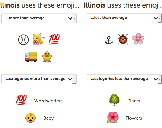
Swiftkey figured out the most and least commonly used emoji in every state. The ones Illinoisians use more than any other state tell an interesting story when strung together.
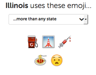
Illinoisans use the gas pump emoji more than people in other states, according to the app SwiftKey.
Cook County (and the entire Midwest) ranked in the bottom third of the best places to live based on their "natural amenities."
Cook County is just barely in the state of Yankeedom, on the border with The Midlands, according to a map put together by author Colin Woodard in his book American Nations: A History of the Eleven Rival Regional Cultures of North America.
An analysis of Twitter reveals the favorite swear words across the country.
Ferris Bueller is the most famous fictional Illinoisan according Playboy; what, no Wayne and Garth? Denied! What do you think?
Boeing is the largest company in Illinois, based on its revenue.
Paying the rent may be a bit easier in Illinois, according to a map of the hourly wage needed to afford a two-bedroom apartment in the U.S.
Deaths caused by respiratory infections are more typical in Illinois than in most other states, according to a map of "most distinctive" causes of death in the U.S.
A study found the most racist people live in the Northeast and Southern U.S., and that Northeast Illinois is less racist than average, by measuring the number of racist searches on Google.
Seems like Chicago should also have gotten Transformers and most of John Hughes' movies in addition to the one on xkcd's Cheat Sheet for Figuring out Where in the US You Are by Recognizing the Background from Movies.
Believing in man-made climate change (and agreeing with 97% of scientists) is more popular in the Chicagoland area than in downstate Illinois.
Reaching peak happiness costs about $71,625 in Illinois, according to a study that found emotional well-being increases with income until it plateaus at a certain point.
Illinoisians leave a tip more often than residents of any other state, according to this collection of what each state has more of than any other. Which is sad, because it's still only 61 percent.
Chicagoland isn't just full of light pollution, it's also really loud.
Using Yelp data, Huffington Post calculated the most disproportionately popular ethnic cuisine in each state. I didn't realize frontier chicken and shami kabobs were that popular.
Vox.com mapped the most distinctive job by state based on their relative popularity compared to other states; Business Insider ran a similar map earlier this year with different results. Illinois is full of railroad workers and groundskeepers, apparently.
According to Mashable and Match.com, "neighborhood" is the most common descriptive word in Illinoisians' (read: Chicagoans') profiles.
Illinoisians are more interested in hawaiian salad for Thanksgiving than residents of other states, according to a study of Google searches by the New York Times.
The country is divided into 11 distinct "nations," according to Tufts professor Collin Woodard in his book, American Nations -- and Chicago is part of Yankeedom. An earlier book, The Nine Nations of North America by John Garreau, put us in The Foundry.
Rick Bayless' pumpkin soup with ancho chiles and apple represents Illinois in the NYTimes' Thanksgiving recipes for each state.
Allegedly Kit Kats are the hottest candy in Illinois candy bowls this Halloween.
The level of inequality in Chicago is comparable to that of El Salvador.
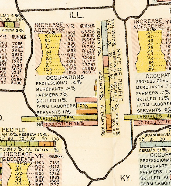
Slate found a 1903 map of "Race and Occupation of Immigrants by Destination" by state. Illinois' immigrants break down about how you'd expect.
Brooklyn Magazine picks Richard Wright's Native Son to represent Illinois in their selections of best the book for each state.
Jawbone shared data by county on when America goes to bed and how much sleep they get on average. Cook County's a bunch of night owls.
A donor heat map shows where people who contribute to political candidates live in Chicago and other cities.
Slate slices and dices the US population in a variety of ways, from dividing the country in half to making concentric circle "states."
Illinois no doubt has Chicago to thank for green bell peppers and Italian sausage being among the most distinctive ingredients by state, according to data from Food Genius.
Illinois gets brownies (introduced at the 1893 World's Fair) in Slate's map of desserts for every state.
The NYTimes' The Upshot blog mapped the percentage of state residents who were born in that state in 1900, 1950 and 2012. Illinois has been fairly consistent.
Did you hear about how men tend to say "uh" and women tend to say "um"? A linguistics professor mapped instances of the two words in tweets county by county. Based on the original "smoothed" map and one with the raw data in the comments, Cook County appears to be split.
Illinois is represented by a weird Prohibition-era "lemonade" stand in Jeff Friesen's 50 States of LEGO. [via]
Chicagoland is home of the Michigimaw and Kaskaskaham tribes, according to a new map of Native American nations. [via]
Agriculture giant Archer Daniels Midland covers Illinois on a map showing the largest companies by revenue in each state; ADM brings in an estimated $89.80 billion.
Halloween represents Illinois on the horror movie map of the US. [via]

There have been 74 school shootings since Newtown, including the murder of Tyrone Lawson after a basketball game in January of last year. Mark Gongloff mapped them.
Map of the 74 school shootings since Sandy Hook. Red markers = K-12. via http://t.co/1YzxxdZUo2 pic.twitter.com/z7FFoCmsC2
— Mark Gongloff (@markgongloff) June 10, 2014In 1910, the largest immigrant population in Illinois came from Germany. In 2010, it was Mexico, according to a Pew Research study.
No surprise that Spanish is the most common language spoken in the US after English. But what's the further down on the list? In Illinois, Polish is third. Slate's Ben Blatt also looked at what the most common Native American, Scandinavian, Indo-Aryan and African languages are spoken across the country. UPDATE: AAPI Voices' Karthick Ramakrishnan points out flaws with some of Blatt's maps, and provides updates.
Vox shares several maps of Twitter data about beer. Chicagoans really like Schlitz and Goose Island, not surprisingly. But we tweet more about church than beer.
Dude, we just hosted C2E2, and Anime Central is in just a couple weeks. How is Illinois 26th in the nation on Estately's Nerdiest States in America map?
Illinois and Rhode Island residents rate their own states least positively in a new Gallup survey, with a quarter of Illinoisans saying this is the worst state in which to live.
The NYTimes put together an interactive map of the dominant baseball team fandom, zip code by zip code. You can probably guess where the line between Cubs and Sox fans is. (Previously, team territories by Facebook likes.)
The Leaning Tower of Niles, just outside the city, gets the nod on HuffPo's list of underappreciated tourists traps in every state.
Geography professor Andrew Shears draws Chicagoland as its own state in a map showing what the U.S. might look like if failed proposals to divide up the states had been successful. [via]
Based on an all-or-nothing analysis of Facebook likes by county, the White Sox own Cook, Will, Kankakee and Lake County in Indiana, and the Cubs own the rest of the region.
Popcorn represents Illinois on Hargreaves & Levin's map of the US in corn. [via]
Chicagoans like sexy POV massages from ebony lesbians in college, according to research from PornHub. [via]
Chicago has been destroyed a number of times by Hollywood, according to a disaster movie map from the Concourse. (Thanks, Dee!)
If Illinois (and the rest of the states) could only eat one meat, what would it be? Slate attempts an answer. [via]
The "signature artist" for Illinois is Sufjan Stevens, according to a developer for music intelligence company EchoNest. (Though weirdly, the results change depending on how deep you go.)
According to an app called Spreadsheets that tracks sexual activity data, Illinoisans do the deed in about 2 minutes, 49 seconds -- or at least those of us who take our iPhones to bed with us do. Nevertheless, we're right about the middle of the pack.
Chicago comes out somewhere in the middle on this map of "pleasant" weather. [via]
A new study describing the relative personality of residents of each state pegs Illinoisians as extroverted and open, but a little less agreeable than the national average. I don't know what they're talking about.
Deadspin ranked Chicago-style deep dis pizza #1 on its rundown of the Great American Menu." Cincinnati chili came in last, below getting hit by a car.
The Jungle is the local pick in Business Insider's map of the most famous book set in every state.
Slate makes the obvious choice for Illinois on its map of the US in which each state gets one signature sport: 16-inch softball.
There have been 3,133 reports of Sasquatch in the past 92 years, all over the country -- including a couple in Chicagoland.
According to this map from the California Rail Map, travel from Chicago to New York would take about six hours by high speed rail, and about 12 hours to LA. [via]
Business Insider and SurveyMonkey Audience asked Americans about their opinions of various states. Not many maps feature Illinois prominently, but those that do are probably about Chicago.
Time Out New York published a map and article picking iconic movies for each state; Illinois got Ferris Bueller's Day Off. Time Out Chicago points out problems with that flick, but doesn't deny it as an option.
Not a map, per se, but the autocompleted Google searches for 50 cities pegs Chicago as corrupt, windy, cold and violent.
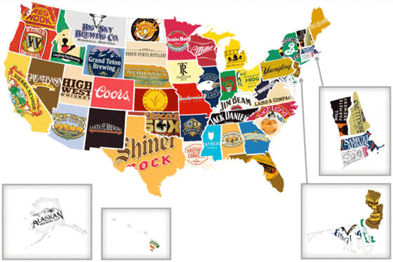
Thrillist's "Red, White and Booze" map of the best-known alcoholic beverage from each state is miles ahead of that corporation map that went around the web last week, while still giving people plenty to argue about.
Caterpillar reps for Illinois on The Corporate States of America map. [via]
A student at NC State University analyzed US dialect data and found some pretty interesting things -- such as that Chicago is "the city" to a pretty good sized region.
Ever get a dollar bill from the Where's George project? A German theoretical physicist has mapped where the dollars go, showing Chicago's pull within the region.
Chicago gets its own state in Neil Freeman's Electoral Reform Map, which creates 50 new states of equal population size. Oddly, the collar counties and Milwaukee end up in the state of Gary. [via]
The Census Dotmap puts a dot on the googlemap for every person counted by the 2010 US Census. Chicagoland, as you'd expect, is pretty well colored in.
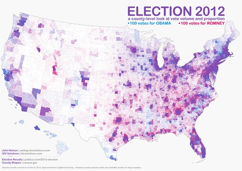
America is not red states and blue states, just purple ones. A new map showing voting patterns in the 2012 presidential election with greater granularity than ever before demonstrates just how true that is.
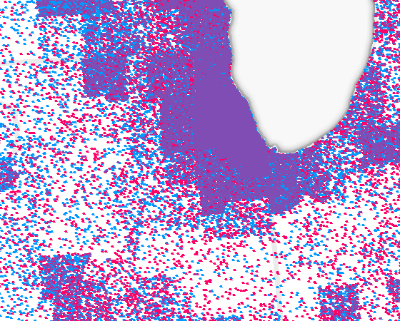
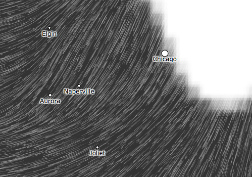
Here's a closeup view of Chicagoland.
Joe Dawson Jr. imagines Illinois as a cat as part of his latest "pet project," Pussies on Parade.
Find out what Google auto-fills when people type "Why is Illinois so..." [via]
XKCD thinks Illinois looks like an upside-down mobster. We got off a little better than Georgia and Missouri, though.
CommonCensus aims to map the true cultural boundaries of America in terms of "sphere of influence." Interesting to see the boundaries of Chicago's influence. (There's also a sports map.)
Advertising Age looks at who is watching what where, using data from Experian Simmons and Patchwork Nation. You might be surprised at Cook County's favorite show.
The Wind Map shows the wind patterns across the entire country. Some stunning portraits here. [via]
You'll never guess where Illinois lands on a study of corruption risk (not corruption itself) in each state. [via]
Whet Moser finds Illinois right where it ought to be on the Geography of Music Preferences: in the middle.
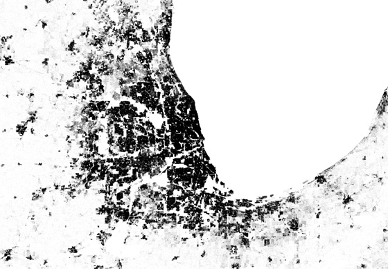
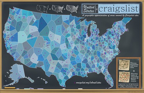
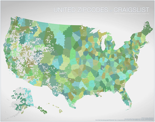
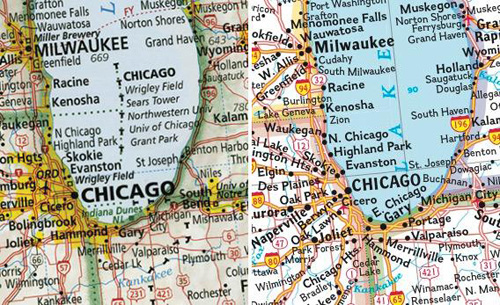
IDV Solutions created a map of the country according to Craigslist coverage areas. It's probably the first time in a century that Rockford was anywhere near as large as Chicago.
Here's a more literal geographic version:
Esquire magazine features a handful of maps that show everything from cellphone use to policies of exclusion and inclusion in Chicago and across the country. [via]
The Food Network made a chocolate map of the country, and northwest suburban Long Grove Confectionery represents for Illinois.
Hey, who are you calling "Sucker," you map of "nicknames of the states" from 1884?
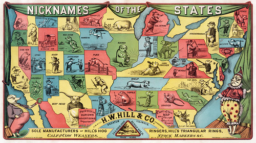
It's especially odd considering the map was produced by a hog ring manufacturer based in Decatur. Maybe "Sucker" was a nice thing in 1884.
Imus Geographics produces a map that Slate calls "the best paper map of the United States you'll ever see." [via]
Cameron Booth mapped the US highway system in the style of the London tube map. He'd already done just the Interstate system. [via]

Cook County comes out just OK, and Illinois is pretty average on Be the Change's Opportunity Index. [via]
I won't spoil the surprise as to what is out to get us on this map, other than to say it's much better than this really lame one.[via]
The Midwest as viewed by Chicagoans. May not be totally accurate.
Chicago's Italian beef is well represented.
Chicagoans spend more money in coffee shops than any other city in America -- which probably says more about the cost of living here than our actual coffee consumption.
Gawker is counting down the 50 states in order of "worstness." Illinois clocks in at #36.
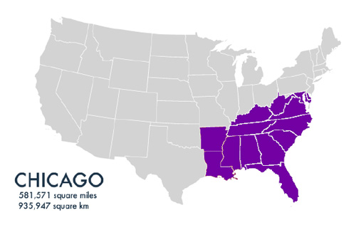
The Per Square Mile project imagined how big a variety of cities would be if the entire world's population lived in them, at their current density. Only problem, they left out Chicago. FoGB Joe Germuska remedied that.
Here's a map of the country according to the most popular films in Netflix for each region. We're apparently into historical documentaries.
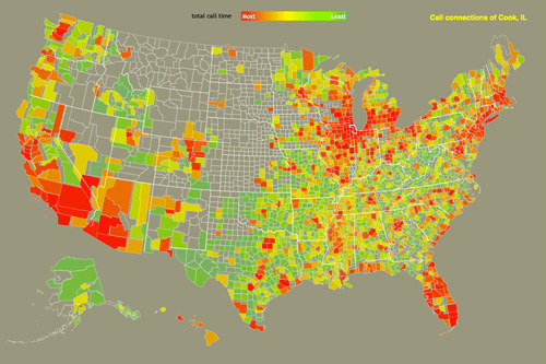
The Connected States of America, a project from MIT, analyzes AT&T call and text data to see what communities arise. See where folks in Cook County are calling. [via]
"Miami of Canada" is apparently the most popular nickname on Twitter for Chicago. Thanks, Mr. Burns.
Illinois bulges with popcorn in Lucy Stephens' "American Gastronomy" print.
Chicago is an Industrial Metroplex on this map of "the 12 States of America."
DelovelyArts offers a slightly revised version of the US map. Illinois represents! [via] UPDATE: FoGB Phineas Jones says, "There, I fixed it."
The United States Bicycle Route Map from the Adventure Cycling Association includes several local routes -- and indirectly leads to the League of Illinois Bicyclists. [via]
More than half of Illinoisans can get stamped at customs when we travel abroad.
The New York Times mapped the Gallup-Healthways Well-Being Index gauging Americans' opinion of their quality of life. They've mapped the results according to congressional districts; Chicago's range from 61 to 69. (The highest I spotted was a 73.)
Illinois comes in 15th in the US (including the District of Columbia) in percentage of population with a current passport -- which, at 34.88 percent, drops us into the second tier on this map.
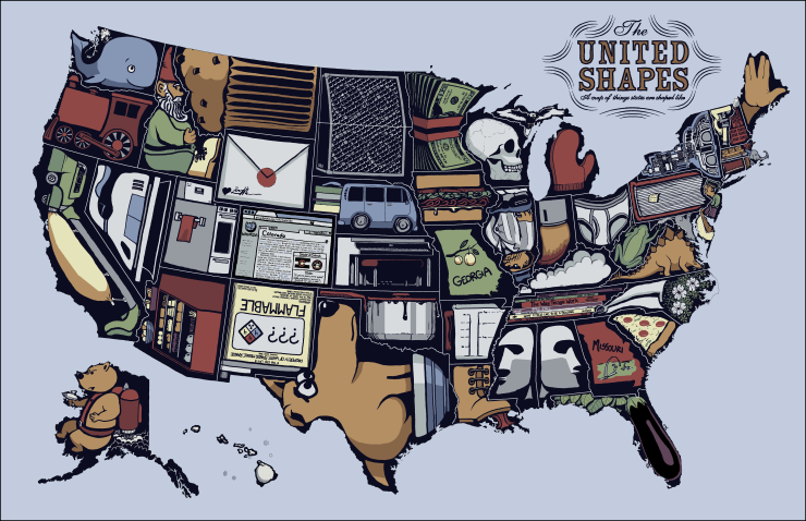
Not a map, exactly, but The United Plates imagines each state as food. Illinois looks tasty.
GOOD puts better brews on their United States of Good Beer. (Previously: 1, 2) [via]
Two maps relevant to today's big event: The United States of Football and beer consumption in the U.S.
Chicago ranks poorly on this map of parkland per person, but at least we have New York and Miami for company.
Since we're all stuck in our homes today, we'll have plenty of time to turn Chicago a brighter shade of purple on this Kinky States of America map.
I wouldn't have pegged the Economist as being into Internet memes, but its commentary on last week's state of the union address includes a familiar-looking map and an old nickname for our great state. [via]
Watch Chicagoland turn darker on this iteractive map of adults with college degrees.
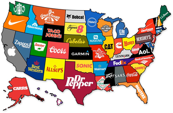
Yep, it's enough of a meme to start doing editions, like google maps a couple years ago. This time, Goose Island reps for Illinois on the United States of Beer, while Green River is ours on the United States of Soft Drinks.